


iHunter Montana app for iPhone and iPad
Developer: Inside Outside Studios Inc
First release : 08 Sep 2014
App size: 149 Mb
Regulations updated annually once released by Montana Fish, Wildlife & Parks.
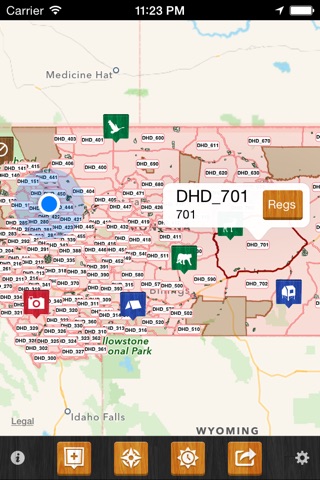
iHunter Montana gives hunters and outdoor enthusiasts a new view into Montanas Hunt Areas. By overlaying the Hunt Areas on top of the built in iOS maps, users can see their current location and which Hunt Area they are in. Dive deeper into specific Areas to see which Deer, Elk, Moose, Sheep, Goat, Wolf, Mountain Lion, Bison, Turkey and furbearer seasons are open. Contribute to the map by adding your own waypoints to keep track of hunting spots, past animal harvests, and landowner contact information.
Features (Most work offline):
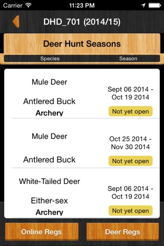
- Includes season summary for 2017 / 2018 (works offline)
- View Hunt Areas on top of built in iOS maps (Hunt Areas display offline)
- View county boundaries, and select them to see game bird and small game seasons (works offline)
- Select Hunt Areas to view a summary of big-game, predator and game bird seasons (works offline)
- 7 different base map types, including 4 that can be cached for offline use
- Add waypoints to the map at your current location, known GPS locations or where you tap and hold (works offline)
- Edit the name, description, image and location of your waypoints (works offline)
- Store Landowner contact information in waypoints to keep track of all your hunting contacts in one place (works offline)
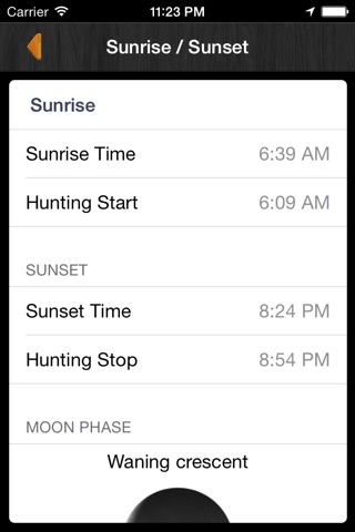
- Use the sunrise / sunset calculator to look up legal hunting light at your location or a waypoint location (works offline)
- Send your friends or family an email with your current location so they can easily find you (requires internet to send email)
- Share waypoints via Twitter and email to friends and hunting partners (requires internet to share waypoints)
- Display Weather at your current location or at a waypoint location (requires internet to look up weather)
- Quick dial button for calling the Turn In Poachers line
- Montana Fish, Wildlife & Parks owned lands boundary layer (works offline)
- Import .gpx files (GPS Exchange format)
In-App Purchases Available:
- In-app purchase to add the iHunter Pro Tools (Search for Hunt Areas by name or number, filter Hunt Areas by species, search the map, most recently viewed list, favorites list, draw over the map and save in a waypoint, track your position, speed and altitude)
Note: The iHunter Pro Tools location tracking feature uses the GPS on your device. Continued use of GPS running in the background can dramatically decrease battery life.